Silverwood Lake Camp & Trail Ride
Get OUTSIDE
04/25/2025 - 04/27/2025
REGISTRATION IS CLOSED FOR THIS EVENT.
Bring your families and camp with us at Silverwood Lake! There is great hiking, biking, off-roading and playing at the Lake.
Friday - Sunday
We will be camping at Silverwood Lake State Recreation area. Bring a Tent, Trailer, or RV!
Trailers and RV’s must be under 31ft. Old Mesa Campground does not have hookups, but New Mesa Campground does.
Location:
Option 1 - 33 miles
Take I-210 North to Waterman Ave
Exit Waterman Ave - Turn left on E 30th St and Right on Waterman Ave.
Head towards Crestline and take the 138/Crestline exit.
Turn Right on to Cleghorn Rd and follow signs to Silverwood Lake and Old Mesa Campground.
Option 2 - 40 miles
Take I-10 West to I-215
I-215 North - Turn left on E 30th St and Right on Waterman Ave
Take Exit 131 - CA138 towards Sliverwood Lake
Turn Left on to Cleghorn Rd and follow signs to Silverwood Lakeand Old Mesa Campground.
Camping:
Silverwood Lake - https://www.parks.ca.gov/?page_id=25893
We will reserve a couple of campsites for our group in the Old Mesa Campground. Camp sites will go to those who register and pay for them on a first come first serve basis. If you want one of these sites it will be $105 for two nights. If you want to book your own site, you can do that through the website above.
Vehicle:
Any vehicle can get to the camp ground.
High clearance for many of the trails and 4wheel drive and lockers for some of the offshoot trail possibilities.
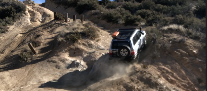
Off-Roading
- Cleghorn Trail Statistics:
- 14 miles
- 2,663 ft elevation gain
- 2,196 ft elevation loss
- Difficulty rating 2-3 (Scale of 1-10)
- Easy to moderate
- Uneven rutted dirt trail with loose rocks, sand, erosion, and washes.
Pilot Rock Trail Statistics:
- 9 miles
- 2,663 ft elevation gain
- 2,196 ft elevation loss
- Difficulty rating 2-3 (Scale of 1-10)
- Easy to moderate
- Uneven rutted dirt trail with loose rocks, sand, erosion, and washes.
- Road is typically 1 vehicle wide with places to pass.
- This is a fun trail, mostly fire road with lots of side trails that can challenge you and your rig.
Pilot Rock Fulebreak OHV Trail Statistics:
- 3.3 miles
- 1,776 ft elevation gain
- 225 ft elevation loss
- Difficulty rating 7 (Scale of 1-10)
- Difficult
- Large ruts, rocks and washouts. Challenging hill climbs and descents - For high clearance and seriously built 4x4.
- This is a side trail that takes off of Pilot Rock Trail and then meets back up with it.
After registering up, we will send a follow up email with more information; campsite info, etc.... and options to pay.
REGISTRATION WILL CLOSE 1 WEEK BEFORE THE EVENT
Media From The Trip
Come back here after the trip to see pictures and videos.